


la môle chapelle Magdeleine

clintest
User
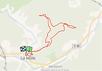

Length
10.3 km

Max alt
274 m

Uphill gradient
326 m
Km-Effort
14.6 km

Min alt
26 m

Downhill gradient
324 m
Boucle
Yes
Creation date :
2023-12-03 08:26:37.915
Updated on :
2023-12-03 13:59:15.864
5h32
Difficulty : Difficult

FREE GPS app for hiking
 SityTrail
IGN / Geographical institutes
SityTrail Plus
The world is yours!
About
Trail Walking of 10.3 km to be discovered at Provence-Alpes-Côte d'Azur, Var, La Môle. This trail is proposed by clintest.
Positioning
Country:
France
Region :
Provence-Alpes-Côte d'Azur
Department/Province :
Var
Municipality :
La Môle
Location:
Unknown
Start:(Dec)
Start:(UTM)
293971 ; 4787086 (32T) N.
Comments